Remote sensing of ecosystem function
Research Highlights:
Massive carbon flux from branchfall in the western Amazon

Myrecent research has uncovered that the flux of carbon to the atmosphere from branchfall is larger than whole tree mortality in the lowland tropical forests of the western Amazon. Over 100,000 ha of forest spanning a 1600 km latitudinal gradient were assessed.
|
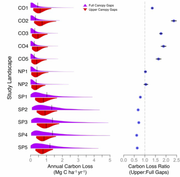
If not properly accounted for the amount of carbon released is enough to shift estimates of an Amazonian forest carbon sink toward a neutral balance or even a source of carbon. While we do not address this particular point in the paper, it is of critical importance for the research community to consider.
|
Read the full paper in Environmental Research Letters here
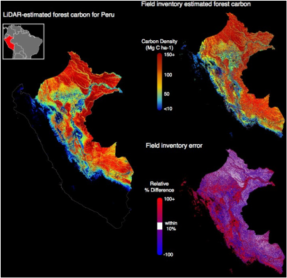
Country-scale carbon maps are incorrect when produced by field plot sampling
|
National forest inventories that use field-plot sampling to estimate forest carbon stocks are the current standard in carbon mapping and monitoring. However, my research has found field plot sampling is unable to produce accurate estimates of spatially explicit carbon stocks at one-ha resolution across more than 25-44% of an example country’s forests (Peru). Tropical forest nations should understand the risks associated with primarily field-based sampling approaches, and consider alternatives leading to more effective forest conservation and climate change mitigation.
Read the full paper in Carbon Balance and Management here |
|
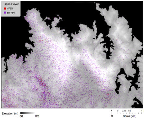
Demonstrating high-resolution mapping of lianas (vines) in tropical forest tree canopies
|
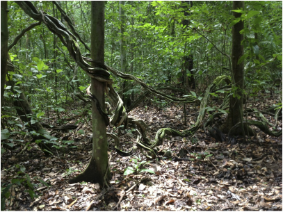
Lianas (woody vines) are major players in tropical forest ecosystems, where heavy abundances lead to increased tree mortality and reduced tree growth. Lianas are notoriously difficult to measure and track their growth over time. Using airborne imaging spectroscopy, we demonstrate the ability to map the abundance of lianas in tree canopies at high-resolution (2 m) across a 2000 ha tropical forest landscape. The accuracy of detecting liana presence-absence was extremely high (90%). Given that levels of liana infestation are increasing in Neotropical forests and can result in high tree mortality, the extent of high-to-severe liana canopy cover across the landscape (see image on left) may have broad implications for ecosystem function and forest carbon storage. The ability to accurately map landscape-scale liana infestation is crucial to quantifying their effects on forest function and uncovering the mechanisms underlying their increase.
|
Read the full paper in the Remote Sensing of Environment here
Major biases uncovered in field-based studies of tropical forest biomass and structure
|
Ecologists have long used field inventory plots as the main tool for understanding forest structure and biomass at landscape-to-regional scales, under the implicit assumption that these plots accurately represent their surrounding landscape. Using airborne LiDAR (light detection and ranging) acquired over three regions in Peru, we assessed how representative a typical set of field plots are relative to their surrounding host landscapes. We uncovered substantial mean biases (9–98%) in forest canopy structure (height, gaps, and layers) and above- ground biomass in both lowland Amazonian and montane Andean landscapes. These biases should temper the use of plots for extrapolations of forest dynamics to larger scales, and they demonstrate the need for a fundamental shift to high-resolution active remote sensing techniques as a primary sampling tool in tropical forest biomass studies.
|
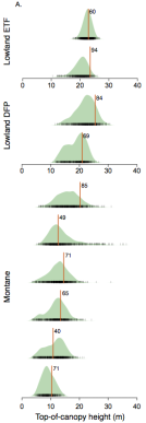
LiDAR landscape data (green) vs. field plot (red)
|
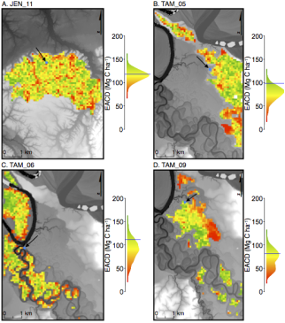
Carbon density mapped with LiDAR across 4 study landscapes. Graphs show landscape data (colored distribution) vs field plot (line)
|
Read the full paper in the Proceedings of the National Academy of Sciences here
Elevated CO2 unlikely the cause of increasing Neotropical lianas (vines)
Read the full paper in Global Change Biology here
|
Recent studies indicate that lianas (woody vines) are increasing in size and abundance relative to trees in neotropical forests. As a result, forest dynamics and carbon balance may be altered through liana-induced suppression of tree growth and increases in tree mortality. The neotropical liana increase has recently received much attention and is often attributed to increasing CO2, yet this hypothesis was untested. Using open-top growth chambers in Panama, this study is the first to measure the relative response of tropical lianas and trees to elevated CO2, and finds no supporting evidence for the increasing CO2 hypothesis.
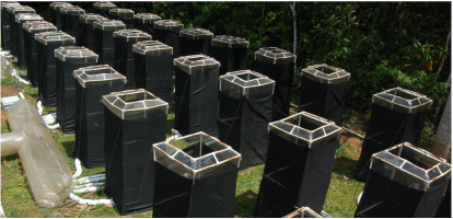
Elevated CO2 chamber array used in the experiments
|
